Plan Change 120 - West Auckland: What you need to know
This is a breakdown of the proposed Plan Change 120 (PC 120), what changes from Plan Change 78 (PC 78), and what it could mean specifically for our burbs in West Auckland.
While PC 120 encourages growth around train stations, upzoning doesn’t guarantee development: market demand, landowner willingness, local geography, risk (flood, landslip), heritage and infrastructure capacity (water, roads, stormwater) will impact what actually gets built in real life.
The plan is still in the proposal / consultation phase: submissions are open now until 5pm, 19 Dec 2025 so West Auckland residents have a real opportunity to influence how PC 120 is shaped. Visit Auckland Council Have Your Say for more information and to make a submission.
In fact, Council have a 'Friend of the Submitter' service who are independent advisors who can help you express your views and have your say. This is free and available now through to Dec 19th. You can find their email addresses here: PC 120 Website (scroll down the page).
Hot tip: when submitting, you can support or oppose any part of the proposed plan change (or do both!). In your submission, it will be helpful to refer to the chapter or rule number from PC 120. This will make it easier for the independent panel to understand your point of view.
Why do we need Plan Change 120 (and why it matters)?
· The government law required two million homes to be allowed to be built.
· Two million comes from the number of houses that could be built if everyone in Auckland developed the maximum size of buildings allowed on their properties all at once. This does not mean two million homes will be built.
· BUT under PC 78 meant councils had to use a one size fits all for planning. High-risk hazard areas or three -storey homes anywhere! PC 120 manages this with more thinking around what to put where.
· The council can’t say ‘no’ to the government order for the required two million homes, but PC 120 allows some areas to have more new homes, and others less.
· Plan Change 120 allows directly for adaptation and resilience in our city.
Smart Alternatives: What Plan Change 120 does:
Removes blanket three-storey housing rules - MDRS (Medium Density Residential Standards).
Introduces better rules and higher standards in flood and natural hazard areas, quickly and simply, reducing future risk to people and property.
Enables density (more apartments, terrace housing, taller buildings) near public transport (train stations, bus corridors). This better aligns housing with recent infrastructure development, particularly the City Rail Link.
Helps infrastructure providers (water, roads, public transport) to better plan future investment to where the capacity will be.
Beware the trolls: What Plan Change 120 does not:
· “Move people out of entire communities, displacing people across New Zealand!”
· Force house insurers to accept high risk and banks to make dud investments.
· Pose any particular change (up or down) to property values in any blanket way.
· Interfere with anyone having a ‘real say’. The consultation to have your say is EXACTLY what it says on the packet.
What this means for Waitakere Local Board area residents
· Mostly, the plan proposes 6‑storey buildings in walkable catchment areas around the train stations.
· This usually translates to THAB (Terraced Housing and Apartment Building, up to six storeys) zoning close to the station and mid‑rise (up to three storeys) housing forms nearby. Then gradually lower densities, the further from the western train line.
· For Oratia, Titirangi, the burbs in the ‘Ranges, and our coastal communities, it restricts density and protects these spaces and their heritage.
· In all cases, there is better ability to protect homes from climate events.
· The plan change doesn’t get into the details around how to manage bins on the street, parking issues, school capacity, congestion etc. But these are things that we (the Local Board) will be able to comment on when someone lodges a consent.
· We will also be better able to support you, the community, raising your voice to Council on hyper local issues that impact you when it comes to someone wanting to develop.
| Feature | Under PC78 | Under PC120 | Good/Bad news for Waitakere? |
|---|---|---|---|
| 1 MDRS (3-storey everywhere) | MDRS made three-storey development allowed in many residential zones. | MDRS as a permitted activity is removed in many areas. This means a down zone to less densification in some areas. | Good news for the entire Waitākere Ranges Heritage protected area and suburbs. This will PROTECT the foothills. |
| 2 Hazard / Flood Risk | PC 78 had limited power to restrict development in hazard-prone zones because of legal constraints. | PC 120 gives stronger tools: more restrictive consent, down-zoning to single house, higher risk assessment bar. | Good news for our coastal suburbs and for homes in the suburbs that are in potential flood zones. |
| 3 Building Heights Near Public Transport | Some intensification, but not as aggressively targeted. | Very tall buildings (up to15 storeys, but more commonly 6) around key train stations on the Western Line. More density the closer to public transport, and closer to the central city. | Medium news for our urban burbs. More housing diversity and affordability for our growing children as they fledge. But potentially more traffic and demand for local services. |
| 4 Infrastructure Planning | More uncertainty, because capacity was broadly enabled. | More clarity on where growth is expected, helping infrastructure agencies plan more precisely. | Good news for all rate payers and residents this means better returns on public investment and potential for improved service delivery. |
A deep dive on our train stations from Glen Eden to Swanson Intensification in Walkable Catchments Information Sheet
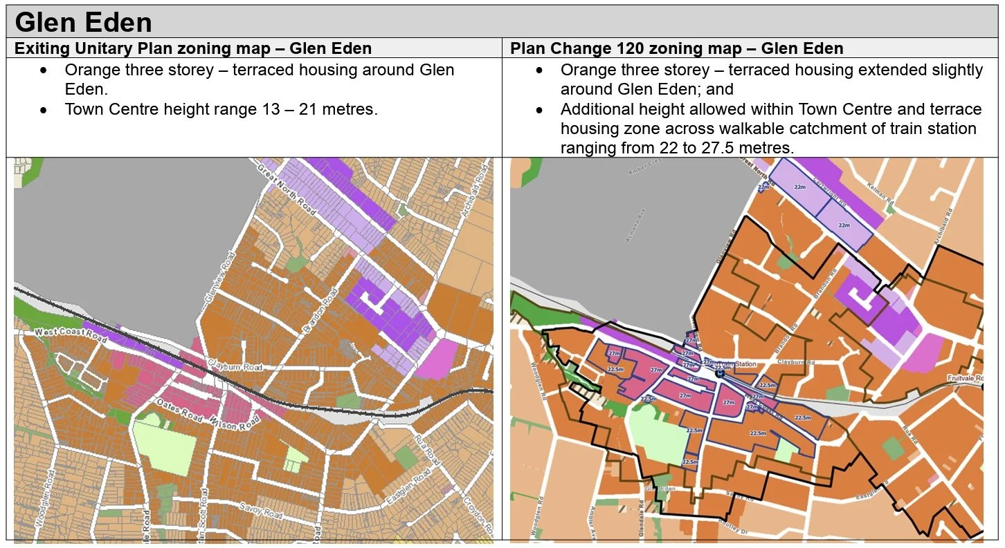
1. Glen Eden:
· A modest expansion of the current Terraced Housing & Apartment Building zone (THAB) near the station. Likely to see medium-to-higher density housing near the station but only up to 6 storeys (or 22.5-27 meters). The Local Board acknowledges this is a growth node, with infrastructure (stormwater, open space, car parking, and the level crossing) being a significant concern.
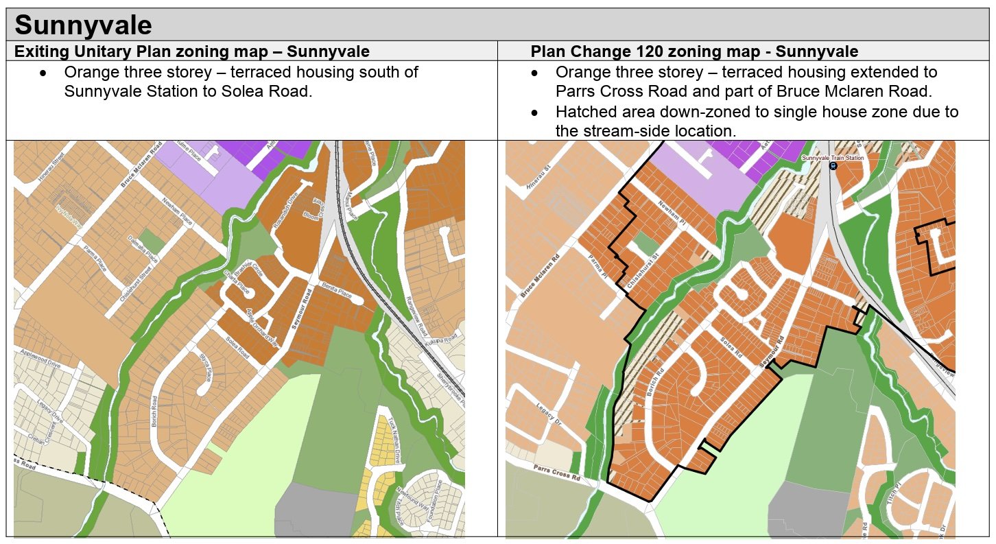
2. Sunnyvale & Rānui:
· A modest expansion of the current THAB (6 storeys) zones are proposed, which could mean townhouses or small apartment buildings rather than very tall towers.
· Sunnyvale – some downzoning due to flood risk.
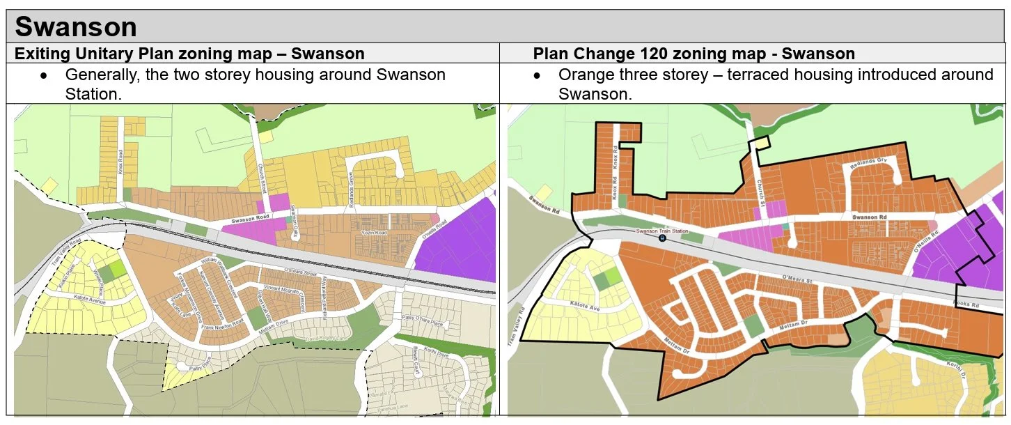
3. Swanson:
· Current Residential – Mixed Housing Urban and Mixed Housing Suburban zones and some parts of Single House zones being upzoned to THAB (up to six storeys). This has been scaled back.
4. Henderson Station:
· PC 120 proposes 15-storey heights in the walkable catchment around Henderson Train Station. But some of the intensification potential (especially taller buildings) could be limited in certain areas by “qualifying matters” — e.g., natural hazards, heritage, etc.
How to use the PC120 map viewer for your house or town centre
Open the PC120 Map Viewer.
Use the search box (property address or suburb/station name). Example for station catchment searches: “Glen Eden Station”, “Sunnyvale Station”, “Ranui Station”, “Swanson Station”, or “Henderson Station”.
Click on the icon on the left of the screen. In the ‘Zoning Layers’ drop-down, turn on the ‘Proposed PC120 zoning’ map layer (if it isn’t already). In the ‘Management Layers’ drop-down turn on ‘Walkable catchments’. In the ‘Spatially Identified Qualifying Matters and/or Planning Matter’ drop-down, turn on Coastal Erosion, Coastal Inundation, and Flood Plains layers to see hazard overlays.
Click on the icon on the left of the screen to view the legend.
Zoom to the station or address and use the measure tool to check the walkable catchment distances (about 400–800 m depending on the category).
For a printable snapshot: use your browser’s Print → Save as PDF, or use the map viewer’s export / share options where available.
What to check on the map: Swanson station, the fringes toward the rural‑urban boundary, and the Waitākere Ranges Heritage Area qualifying matter overlays.
Proposed change: Swanson is more constrained — PC 120 proposals show limited intensification there (Swanson is near the rural‑urban boundary and heritage / landscape overlays that restrict taller development).
Quick links
PC 120 Map Viewer (interactive) — open this first.
Auckland Unitary Plan map viewer (property-level) — this map shows the current planning rules.
PC 120 information & explanation (Auckland Council ‘Have Your Say’ page) — background, timelines, FAQ, public information webinars.